Archive for March, 2008

 Tallapoosa darterThe “4th Annual State of Our Watershed Conference – The Tallapoosa River Basin”, coordinated from the Alabama Water Watch office in the AU Department of Fisheries, is for all who are interested in learning more about the health of streams, lakes and rivers of the Tallapoosa River Basin, the development plans for Lake Martin and visions of policy makers, watershed management strategies, and community participation in management of water resources of the basin.

Conference Information:

Location:      Central Alabama Community College, HEA Auditorium, 1675 Cherokee Road, Alexander City, AL

Date:      Friday, April 11th, 2008

Cost:     FREE registration and A FREE LUNCH will be provided

Topics:      Drought impacts, upgrading Lake Martin to Outstanding Alabama Water, Lake Martin dam relicensing, community-based watershed initiatives, and the role of the AU Water Resources Center in management of the Tallapoosa River Basin

Register:     To register (required),  visit the Tallapoosa Watershed Project web site at: www.twp.auburn.edu

Thanks to Dick Bronson at Lake Watch for submitting this event to the Lake Martin Voice!

little kowaliga creek bridge
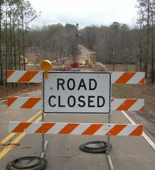
If you have a Lake Martin house in the Little Kowaliga area, you are well aware that Little Steel Bridge Road aka Elmore County Road 55 is closed.  If you are heading to the Real Island or Parker Creek areas of Lake Martin, and are coming from the south, be aware that you must detour.  Keep going north on highway 9, when you hit downtown Equality, take Coosa County Road 2 east.

I have a home for sale near Real Island, and was heading over there last Friday.  I took that chance to snap these pictures.  I came away with a few observations:

a.)  Little Steel Bridge is steel no longer.   Mostly concrete with some steel girders thrown in for good measure (read engineering).

b.)  It’s going to take a while to complete.  Get used to the detour.

c.) Will they change the name of the road?  Unlikely.

lake martin bridge construction


lake martin waterfront property


lake martin maps directions


 lake martin waterfront lots

Lake Martin Maps: Pre Civil War And Web 2.0

Posted By: , March 9th, 2008

Lake Martin map
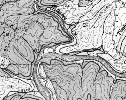
For anyone that likes old maps of Alabama – or if you would like to see what your Lake Martin property looked like before the lake was built – I have a great site for you. 

The University of Alabama is a great site resource for these old maps.  Some of them date back to the early 1800s.   Here are links to Lake Martin counties:

Old Tallapoosa County Maps  Old Elmore County Maps  Old Coosa County Maps

Click this link for other Alabama CountiesHat tip to boataholic on the Lake Martin Forum for the heads up on this link!

While I’m on the subject of maps, please click on my map of Lake MartinI have made a Google Map that shows Lake Martin marinas, restaurants, my listings of Lake Martin real estate for sale, and Coley Real Estate office locations.  If you click on any of the listings, I have added in little pictures of the homes for sale, links to their information on my blog, and also links to their online video tours

Since it’s a Google Map, you can switch back and forth between street map view and satellite photo images.  They recently have updated parts of Lake Martin with the ability to really zoom in tight, so it might be fun to zoom way into your spot on the lake.

Active Listings

lake martin foreclosure home sale bank reo

Facebook

Local Resources

Twitter

Archives

Blogroll

ActiveRain Real Estate Real Estate Blogs - Blog Top Sites  Add to Technorati Favorites Success Session Graduate