Lost At Lake Martin? Use Google’s Free Maps For Mobile

Lake Martin Real Estate Spotlight: Eagle’s Point
December 1, 2007
All Real Estate Is Local (This Means You, Lake Martin)
December 7, 2007Lost At Lake Martin? Use Google’s Free Maps For Mobile

Ever been lost around Lake Martin? Has anyone given you bad directions to their cabin and frustrated you by relying on the term “can’t miss it?” If you were looking for 1135 Lakeview Drive, Dadeville, how would you like to be able to see this map on your cell phone:
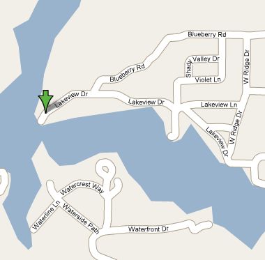
Download Google’s Maps for Mobile on your cell phone and greatly diminish your odds of getting lost around Lake Martin.
Top 5 Cool things about Google Maps for mobile:
1. It’s free. The software from Google is free. You will pay, however, for the data that you download, so if you don’t have some sort of Internet data package with your cell phone you will be charged. If you have an unlimited data package – no worries! Even if my blackberry didn’t have unlimited data, I still would pay to download this, so I would have it in an emergency.
2. Google Maps for Mobile is accurate – even around Lake Martin. You are accessing the same data that Google Maps shows you on your PC – just in a format that is easy on mobile web surfing. Sure, it won’t have brand new roads, but it’s better than the most recent paper map.
3. It’s Searchable – let’s say you were in the Blue Creek area, riding around highway 50 by Martin Dam and were looking for somewhere to eat lunch. You can find your location and then search for “restaurant” – here’s what you would see:
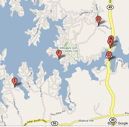
You can click on any of these and be told their address and phone number.
4. “My Location” feature turns your cell phone into a GPS. This new feature uses cell phone towers to triangulate your exact location. Cool as crap. Availability and accuracy of this depends on where you are. I have not found a place on Lake Martin that it works. It works pretty well on Lake Martin. Depending on your cell coverage, it can place you from 1,000 to 5,000 meters. It works in Montgomery, though. If you think that the CIA will use it to track you, you can opt out of the My Location feature and still use Maps for Mobile.
5. No further software needed. GPS companies like Garmin etc have products that you can download for $99 and then pay a recurring fee through your cell phone provider– all to get the same thing as this. Lake Martin lovers need only download Google Maps for mobile software, that’s it. Click here and Google will send you a link to download it.